Misamis University was contracted by the DENR-MMRNP PAMB to identify a 60 km Management Zone inside Mt. Malindang Range Natural Park, Misamis Occidental.
The Misamis University Community Extension Program (MUCEP) again, was tasked by the Department of Environment and Natural Resources, Provincial Environment and Natural Resources Office, Oroquieta City, relative to the 2019 management zoning target of about 60 kilometers in length within the protected area of Mt. Malindang Range Natural Park located in the province of Misamis Occidental.
Mt. Malindang Range Natural Park (MMRNP) encompassing the province of Misamis Occidental covers 53,028 hectares and 34,694 hectares of which is designated as Protected Area (PA) while the remaining 18,334 hectares is classified as buffer zone which serves as protective layer of the PA to contain impending peripheral harmful impacts from reaching therein.
The management zoning in the Protected Area ( 34,694 hectares) is not yet properly implemented as mandated under DAO 2008-26 Rule 10 as quoted “Each protected area shall be divided into two management zones: strict protection zone and multiple use zone consistent with its designated category”. Consequently, there are settlements and development within the PA presently categorized as within the ‘strict protection zone” but its actual use is for a Multiple Use Zone.

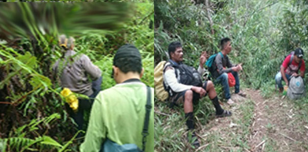
| Photo from left: Management Zoning activities were supervised by Mr. Eden C. Pito, MUCEP Staff. The local guides accompanied the team in establishing the Multiple Use Zones and Strict Protection Zones. One of the agricultural products geo-tagged is the Call Lily plantation in Barangay Lake Dumingat which was then recorded under the Agricultural Zone- a sub-zone of the Multiple Use Zone. |
To address present issues on zoning in the park, the DENR issued BMB Technical Bulletin No. 2018-01 “Clarifying the Procedures in the Identification, Designation and Delineation of Management Zones of Protected Areas under the National Integrated Protected Areas (NIPAS)”. Its main objective is to delineate zones/land uses within the protected area of Mt. Malindang into Multiple Use Zones and Strict Protection Zones. The delineation of the protected area is important in the proper management of Mt. Malindang in biodiversity conservation and sustainable development. It will provide basis for resource allocation and acceptable uses by considering the characteristics, benefits and potentials of the area.
The PA management zoning is a wise initiative to put all things in proper perspective. To sustain the support of park occupants and making them more effective partners in the protection and conservation of the park, it is imperative to address their concerns by implementing proper management zoning. The zoning of Mt. Malindang will establish areas where occupants can utilize the area (the multiple use zones) consistent with the various laws, and the strict protection zones which include sanctuaries of important species, geo-hazards and permanent danger areas and closed to human activities except for research and ceremonial and non-destructive uses by the Indigenous People (IP).
Prior to the actual conduct of ground survey and zoning activities, coordination and consultation workshops were conducted that were participated with concerned LGUs which was initiated by MUCEP with the assistance of the DENR. These consultations aimed to smoothly accomplish the activities of the management zoning. Alfredo F. Garrido Jr., Director of MUCEP, led the actual survey of the management zoning with the support staff from MUCEP and College of Engineering, staff from DENR-PAMO and Local residents. Forester Jersam C. Calago, the GIS specialist was responsible for generating the maps coming from the data in the field to be submitted to the DENR.
The target areas covered by the management zoning were Barangay Sebucal, Oroquieta City, Barangays Lake Duminagat, Gandawan and Lalud in the Municipality of Don Victoriano Chiongbian and Barangay Fertig Hills formerly Hoyohoy in Tangub City.
Results of the management zoning in the five barangays revealed that the multiple use zone of Brgy. Sebucal measures 15.78 km in terms of ground distance with an area of 381.6 has. This zone was further sub-divided into four (4) sub-zones namely: Eco-tourism, Settlement, Agriculture, and Trails. For Barangay Fertig Hills, the multiple use zone of the barangay was intended for the Gardens of the World which is the ecotourism site of the City of Tangub, Misamis Occidental which has a total distance of 12.36 km.
Relative to the identified multiple use zone of the Barangay Lake Duminagat that covers a total ground distance of 14.0 km. There are four (4) sub-zones identified based on its present use to include: Eco-tourism, Settlement, Agricultural and Trails while the multiple use zone of Brgy. Gandawan measures 4.15km in terms of ground distance with an area of 30.59 has. This zone was further sub-divided into four (4) sub-zones namely: Settlement, Agriculture, Trails and Irrigation canal. Lastly, the initial area of Barangay Lalud for multiple use zone is 7.39 kilometers subdivided into 2 sub-zones namely Ecotourism and Agriculture.
The Misamis University is thankful to the DENR for funding the management zoning activities, as well as the positive support of the concerned LGUs and local communities in undertaking the activities. MU is optimistic that the generated results will help the DENR, PAMB, LGUs and local communities to propose and follow later sound decisions for better management of Mt. Malindang.
Announcement

|

|

|
Photo Gallery
 Turnover of solar energy management from WEGEN to MU
|
 MU Sinulog Celebration 2026
|
 MU Winter WonderLand Christmas Party 2025
|
Videos

|

|

|


